Pluvial flooding: Protecting your property from a growing risk
Climate and EnergyArticleApril 20, 2026
Building and preparing for a 100-year flood has traditionally been regarded as sufficient protection against these seemingly rare weather events. However, taking into consideration climate change, extreme weather trends and overburdened stormwater infrastructures across the U.S., it may be wiser for property owners to protect themselves from flooding outside of 500-year floods. If that sounds far-fetched, unfortunately, it’s becoming the reality.
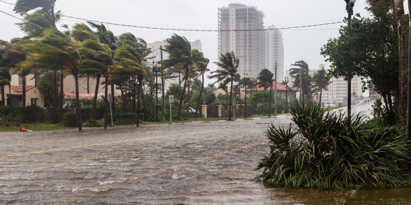
The increase in severity and frequency of pluvial flooding – a term that includes both flash floods and surface water runoff – continues to plague communities and businesses across the U.S. The year 2025 was record-setting for flash flood emergency warnings from the National Weather Service, with almost 4,000 of these alerts sent in just the first seven months of the year.1 Even more daunting is Zurich Claims data that shows more than 50% of flood claims are occurring in areas designated outside the 500-year flood plain by the Federal Emergency Management Agency (FEMA). These higher-elevation areas, traditionally considered lower risk for flooding, are increasingly threatened by pluvial floods. And so, subsequently, is the property built upon them.
A 2025 reinsurance industry report found that pluvial flooding caused by extreme rainfall is becoming more frequent and severe across many urban and suburban areas, often impacting properties previously considered low risk. Many such losses occurred outside Special Flood Hazard Areas, which contributed to significant underinsurance among commercial property owners.2
What is pluvial flooding?
Pluvial flooding is a term that will gain notoriety as long as urbanization and the severe weather patterns fostered by climate change continue to collide. It happens when extreme precipitation drops several inches of water in a short period of time, overwhelming the ability for the affected area to efficiently remove the water. Melting snow can also contribute to these events. (This is in contrast to fluvial flooding, caused by rivers and other bodies of water overflowing their banks.)
In recent years, an increase in the total amount of precipitation has resulted from these intense single-day events, according to the Environmental Protection Agency (EPA). A recent EPA report, citing records that date to 1901, found that global precipitation has increased at an average rate of 0.04 inches per decade, while precipitation in the contiguous 48 states has increased at a rate of 0.20 inches per decade.3
Convective storms are a leading driver of pluvial flooding
A 2026 industry report found that severe convective storms have now surpassed tropical cyclones as the costliest insured perils of the 21st century, largely due to high-frequency, high-severity events producing extreme rainfall and surface flooding in more densely developed and populated areas. During 2025 alone, insured losses from severe convective storms reached $61 billion globally, with the U.S. accounting for a significant share due to concentrated development exceeding the ability of aging flood-control infrastructure to respond.4
Unfortunately, many urban drainage systems were built for rainfall assumptions that no longer reflect current conditions. Urban flood modeling research published in 2025 found that a majority of stormwater drainage networks exceed capacity during moderate‑to‑severe rainfall scenarios, significantly increasing the likelihood of surface flooding even during non‑catastrophic storms.5
As commercial and residential development expands across the U.S., increasing the scope of impervious surfaces such as asphalt and concrete, runoff volumes will rise as the ability of surrounding natural environments to absorb such runoff will decrease, amplifying the stress on already aging and inadequate drainage infrastructure.6
Different types of pluvial flooding
Two types of pluvial flooding can challenge communities and stormwater systems:
Surface water floods
Surface water flooding occurs when rainfall is not absorbed by the ground as it travels to a body of water (e.g., a river, creek, or drainage basin). When this happens, water may collect in low-lying areas, which then can affect below-grade spaces with or without a drainage system present. With nowhere to go, the water can collect on streets and into surrounding structures. Because this surface water typically rises gradually and remains shallow, people fortunately have time to move to safety. Although surface water flooding usually creates no immediate threat of loss of life, it may still cause significant economic damage to property.
Flash floods
Flash floods are characterized by an intense, high-velocity flow of water triggered by torrential rain that falls within a short amount of time, impacting the immediate vicinity and nearby elevated terrain. On July 4, 2025, a flash flood killed 138 people in six Texas Hill Country counties, including 25 young girls and two counselors at Camp Mystic in Kerr County, after the area received 12 inches of rain in 12 hours.7 In 2021, a deadly flash flood in the New York City/New Jersey area driven by rainfall from Hurricane Ida resulted in devastating flooding and over 40 deaths. Six to 10 inches of rain fell within a few hours in a region with a historical rainfall average of just four inches for the entire month of September.8
Flash floods can also occur when there’s a sudden release of water from an upstream levee or a dam. Flash floods are extremely dangerous and destructive, not only because of the water’s force, but also from hurtling debris swept up in the flow. These “debris flows” can strike without warning, destroying everything in their path.
How severe is the risk from surface flooding?
Surface flooding can lead to catastrophic damage. This was observed in the flooding that resulted from 2017’s Hurricane Harvey in Houston, which dropped 27 trillion gallons of water in Texas and caused about $125 billion in damage.9 More recently, some of the heaviest rain on record fell in the San Diego, CA, area in January 2024, causing millions of dollars in damage to homes and businesses.10
For businesses, pluvial flooding losses from operational disruption can be as great a burden as total property loss. A national commercial flood risk assessment found that over the next 30 years, downtime days for commercial buildings due to flooding are projected to increase by nearly 30%, highlighting the growing business interruption exposure associated with pluvial flooding.11
Surface water runoff management is critical
The catastrophic potential of surface flooding challenges the assumption that large flooding risks only occur near a significant body of water. Surface water runoff is playing a growing role in flooding events and needs to be better accounted for in flood risk.
Urbanization is a significant cause of surface water flooding because less permeable surfaces such as concrete and asphalt are replacing the natural flood protection provided by water-absorbing grasses, plants, trees, and wetlands. Urban flooding results in $9 billion in damages every year, notes the American Society of Civil Engineers (ASCE).12
Stormwater infrastructure is struggling to keep pace with the growing demands of extreme weather and the proliferation of urban development. Not only are many of these systems aging, but they were also built to accommodate rainfall averages and models that are far more modest than today’s reality.
Preventing surface water flooding
New building projects, including buildouts on existing property, can alter the flow of stormwater as well as the ability for existing infrastructure to handle the surface water. This also includes the need to address the potential degradation in surrounding-ground grading, which can cause unintended consequences to water flow or even water ponding in other areas of your property or a nearby neighbor’s.
Moreover, the problems can literally have a ripple effect, impacting local or even downstream communities where the drainage system connects enroute to the ultimate outlet.
Why pluvial flooding is such a difficult risk to anticipate
Flood maps from FEMA, though not the only mapping reference to predict the risk of a property to flooding, are probably the most familiar guide for planners, builders, and homeowners alike. Unfortunately, these maps have limitations:
- FEMA maps typically account for fluvial flood hazards but usually do not account for pluvial impact nor the combined impact of fluvial and pluvial flooding.
- The maps do not account for all streams and watersheds in the U.S. The Association of State Floodplain Managers estimates that only about a third of the nation’s rivers and streams, and 46% of shorelines, are represented.13
- Although updates are scheduled every five years, many maps have been found to be older. This is especially problematic given the speed with which urbanization has continued alongside significant weather events of recent years. For example, there are properties in New York City that experienced flooding during Superstorm Sandy (2012) but are still not required to purchase flood insurance because FEMA and the city recognize maps from 2007 that understate the actual flood risk around the five boroughs.14
- FEMA only maps U.S. locations.
Recent industry research notes that traditional flood maps often fail to capture rainfall‑driven flooding, underscoring the importance of integrating local terrain, infrastructure capacity and exposure characteristics when evaluating flood risk for commercial properties.
As flood risk evolves, insurers and risk engineers are increasingly shifting from hazard‑based mapping to risk‑based assessments that consider site‑specific conditions. This approach supports more informed risk mitigation strategies and underwriting discussions, particularly for properties outside mapped flood zones.15
How businesses can better manage pluvial flood risks
Given the changing tide of flood risks, property owners need to adopt a more nuanced understanding of pluvial risks. For instance, different areas of a property may pose different flood risks. The flood risk at the entrance of a property can be dramatically different from, say, the back of the site with acres of asphalt parking lot, or areas adjacent to different types of grading.
We’re not suggesting rejecting FEMA maps. When it is up to date, FEMA mapping considers only accredited or provisionally accredited levees, includes levee condition, and provides onsite assessment of river channels and overpasses. These are all beneficial when evaluating fluvial flooding, which in turn should be considered along with pluvial risks for an optimal understanding of overall flood risk.
A closer look at climate risk
To take a more comprehensive view of flood hazards, Zurich Resilience Solutions (ZRS) has incorporated new technology to help our customers identify and understand the growing challenges of pluvial flooding. Tools that can help identify pluvial risks at various location levels of any given property.
Within a broad menu of ZRS services, a special focus on Extreme Weather Resilience recognizes the growing risks facing businesses due to severe convective storms and pluvial flooding. And a unique Zurich resource – Climate Spotlight – can help businesses assess future flooding through a review of potential climate scenarios. Climate Spotlight addresses a common blind spot that may exist in many of the flood hazard map resources currently available.
Zurich Resilience Solutions Risk Engineering professionals will make multi-faceted assessments with a risk-based, rather than a hazard-focused, approach. Though the initial hazard level will be determined from a hazard map, we will then take into account a variety of hazard characteristics not included in the maps. Our assessments also incorporate additional, relevant information for a particular site, including but not limited to event duration and local terrain conditions, such as urbanization that reduces soil absorption, or potential contaminants, such as underground storage tanks, etc. The critical exposures at a location (e.g., buildings, contents and/or storage) that could be threatened by the hazard are also considered as part of the assessment.
By combining information from different data sources, Zurich can help customers better identify both fluvial and pluvial risks for a more complete overall understanding of their flooding risk.
For more insights to help businesses prepare for, respond to and recover from floods, visit Zurich’s Flood Resource Hub.
To learn more about pluvial risks and how Zurich can help you get a more complete picture of your property’s flood risk, email Zurich Resilience Solutions-Risk Engineering.
Visit Zurich’s Property website to explore our wide range of tailored, holistic solutions to help customers of all sizes protect their entire portfolio of business.
References
- “2025 Is Now the Most Flash Flood-Warned Year to Date.” Baron Weather. 1 August 2025.
- “Flood insurance demand surges in 2025 as Guy Carpenter warns of expanding risks.” Reinsurance Business. 5 March 2025.
- “Climate Change Indicators: U.S. and Global Precipitation.” Environmental Protection Agency. Updated 7 July 2022.
- “Severe Convective Storms Now the Costliest Insured Peril of the 21st Century, Aon Reports.” Aon Media Room. 20 January 2026.
- “An Enhanced Framework for Assessing Pluvial Flooding Risk with Integrated Dynamic Population Vulnerability at Urban Scale.” MDPI Journal. 14 February 2025.
- Ibid.
- “Texas Flood Was America’s Deadliest Rainfall Flash Flood in 49 years.” The Weather Channel. 29 July 2025.
- Hershner, Monica and Nigel Chiwaya. “Map: Here's How Much Rain Ida Dumped on the Northeast.” NBC News. 2 September 2021.
- “Hurricane Harvey.” The Texas A&M University System. Accessed October 2021.
- California declares emergency after San Diego 'thousand-year storm' - Los Angeles Times (latimes.com).
- “Commercial Real-Estate at Risk: An Examination of Commercial Building and Economic Impacts in the United States Using a High-Precision Flood Risk Assessment Tool.” Frontiers. 2 May 2022.
- “Stormwater: 2021 Report Card for America’s Infrastructure.” American Society of Civil Engineers. Accessed October 2021.
- “Flood Mapping for the Nation.” Association of State Floodplain Managers (ASFPM) Foundation. January 2020.
- “10 Years After Superstorm Sandy: The Paradox of More Flooding and Less Insurance | Moody's RMS" Moody’s October 27, 2022.
- “How will the U.S. flood insurance market evolve amidst rising risks and modeling advancements?” Moody’s. 17 July 2024.